Drawing a Map
-
alhoon

- Invisible Menace

- Posts: 8813
- Joined: Thu Dec 11, 2003 6:46 pm
- Location: Chania or Athens // Greece
Re: Drawing a Map
Really? But how could they stop invaders with bamboo walls?
"You truly see what a person is made of, when you begin to slice into them" - Semirhage
"I am not mad, no matter what you're implying." - Litalia
My DMGuild work!
"I am not mad, no matter what you're implying." - Litalia
My DMGuild work!

Re: Drawing a Map
If you're relying purely on static defenses to stop an enemy invasion, you're doing it wrong. Much as the French learned so painfully in the early months of WWII, when their expensive Maginot Line of defenses failed to stop the German Panzer advance.
-
ewancummins

- Evil Genius

- Posts: 28523
- Joined: Tue Oct 25, 2005 1:35 pm
Re: Drawing a Map
alhoon wrote:Really? But how could they stop invaders with bamboo walls?
You stop them using men with spears and bows behind or atop the walls.
Delight is to him- a far, far upward, and inward delight- who against the proud gods and commodores of this earth, ever stands forth his own inexorable self.
-from Moby Dick (Hermann Melville)
-from Moby Dick (Hermann Melville)
-
alhoon
- Invisible Menace
- Posts: 8813
- Joined: Thu Dec 11, 2003 6:46 pm
- Location: Chania or Athens // Greece
Re: Drawing a Map
Yeah, but static defences help HMB.
Ewan: And when those enemies use catapults to hit the walls beyond your range? I still find it ... expensive manpower-wise to defend wooden walls.
Ewan: And when those enemies use catapults to hit the walls beyond your range? I still find it ... expensive manpower-wise to defend wooden walls.
"You truly see what a person is made of, when you begin to slice into them" - Semirhage
"I am not mad, no matter what you're implying." - Litalia
My DMGuild work!
"I am not mad, no matter what you're implying." - Litalia
My DMGuild work!
Re: Drawing a Map
At risk of going even more off-topic, let's clarify:
1. Build static defenses as the lay of the land and economics allow. If you experience earthquakes every few decades, then spending a few years to build static defenses against insurrections that might happen once a century is unrealistic and you're better off spending money elsewhere.
2. "Static defenses help", as you say, is generally correct. So is "don't rely entirely on static defenses", as I say. I'm not sure why you're implying these two statements are mutually exclusive. My argument is that a military force may not need static defenses in a given situation (e.g., living in an island nation prone to frequent earthquakes), or may find them prohibitively expensive.
3. "Catapults would make short work of flimsy defenses." Why would an enemy build catapults if there aren't any enemy hardpoints to attack? Armies innovate siege engines to counter harder static defenses, which humans cannot effectively take out on their own. If there aren't any static defenses, what use would a catapult have? This is even more severe than with cannons, which at least have some disruptive use against massed enemy ranks. Catapults are pretty much as strong as they need to be to crack an enemy hardpoint defense. Any stronger and you're wasting time and resources on developing unused offensive capability.
All the above questions essentially boil down to one point - if it's more effective, efficient, or economical to use humans rather than siege engines or siege defenses, most rational systems will indeed opt for the human option.
-
ewancummins
- Evil Genius
- Posts: 28523
- Joined: Tue Oct 25, 2005 1:35 pm
Re: Drawing a Map
alhoon wrote:Yeah, but static defences help HMB.
Ewan: And when those enemies use catapults to hit the walls beyond your range? I still find it ... expensive manpower-wise to defend wooden walls.
Fortifications are a force multiplier, yes. We should consider a number of factors when asking why some towns in 'medieval' Japan used bamboo walls, and most did not use stone walls.
1)Earthquakes and economics: As previously noted, this is a big factor in Japan. What good is it to spend resources , money, and manpower your village can scarcely afford on a stone wall that falls down when a big tremor hits? A bamboo palisade is less likely to collapse in a quake, and much cheaper and faster to rebuild.
2)The enemy: Most 'medieval' Japanese villages with a bamboo wall were probably worried about raiding bandits or lightly equipped soldiers. Catapults existed in 'medieval Japan', but how often would raiders employ such weapons? My guess is not very often, but someone more knowledgeable about pre-modern Japan may be better able to answer that question.
3)Technology:
The technology of building stone fortifications may simply have not been developed in Japan at the time of the bamboo walled towns.
In Japan, castles/forts were built larger and with more masonry after cannon and firearms were introduced.
In Norman England, many castles were built of wood atop hills or artificial mounds. Sophisticated stone castles were a later development, and reflected changes in building technology and siege warfare.
Neither catapults nor cannon eliminated fortresses in Europe or in Japan, but weapons and tactics certainly helped spur new defensive technologies.
***
RE The Maginot Line--
The Maginot Line was never completed for political and budgetary reasons. It did not run the whole length of the border. Based on what I have read, the fortifications alone were not intended as an 'impregnable' defense that France could absolutely rely upon to stop the Germans. The Line was supposed to slow down any advance long enough for the French to fully mobilize their reserves. The French army would then repel the invaders. Budget cuts shrank French military power through the interwar years, and left the castle wall without enough men to defend it, so to speak.
Another factor to consider is that technology and tactics changed between the time the fortifications were planned and the WW2 German invasion of France.
Delight is to him- a far, far upward, and inward delight- who against the proud gods and commodores of this earth, ever stands forth his own inexorable self.
-from Moby Dick (Hermann Melville)
-from Moby Dick (Hermann Melville)
-
MichaelTumey
- Evil Genius
- Posts: 451
- Joined: Sat Jun 11, 2011 3:23 pm
Re: Drawing a Map
Himeji Castle, one of the largest castles in Japan, had 3 rings of moats with a greater distance over the 3 moats, than what most catapults could throw stones across. For those later castles, this was the primary static defense.
As Ewancummins suggests, those bamboo walls were defended by foot soldiers with spears, bows and later with arquebus. Regarding such siege machines as battering rams. Japanese castle interior gates featured gates that sit 90 degrees from the direction of flow between walls. So if you manage to break a gate with a battering ram, your besiegers discover upon passing the gate, that a huge force of men awaits them beyond the gate, from within the walls firing from loopholes or from towers at corners and flanking the gates - once they get through the gate, they cannot effectively turn the battering ram 90 degrees under heavy fire to use it again. Thus battering rams were one use items in castle siege, so wasn't used much.
Most Japanese castles featured 3 sets of baileys, that is 3 sets of concentric walls (each interior area is called a bailey) with 90 degree gates to enter each bailey, and the next gate was on the other side of the complex. This forces attacking units to have to travel all around the castle within ranged fire to reach the next gate. Also the donjons or main multi-level castle structure which sits in the center bailey, is surrounded by smaller similar looking donjon towers at critical points in the wall and at corners. These smaller towers exactly resemble the main fortress, perhaps with fewer levels. This tricked many units to attack a lesser tower thinking it was the main tower. This design created subterfuge in the heat of battle.
Another issue is knowing how many troops are inside a given castle. When you look at a Japanese castle you will note multiple floors rising up. Calculating the number of floors in a fortress attacking troops could guess how many troops awaited them by counting the levels. The problem here, more subterfuge, many such castles had hidden floors within the roof structures that separate levels, so that more troops could be placed so attacking forces might attack with under strength force.
Japanese static defenses indeed existed, but were different than European defenses for reasons of technology, earthquake considerations, cost, etc.
Many Japanese castle towns featured the same winding nature of baileys, in the standard street grid of a town, forcing troops to have to travel all around the city just to reach inner sections of the city. This design function was not used in the above map.
-
alhoon
- Invisible Menace
- Posts: 8813
- Joined: Thu Dec 11, 2003 6:46 pm
- Location: Chania or Athens // Greece
Re: Drawing a Map
talk talk talk... and no map of a Japanese castle!
"You truly see what a person is made of, when you begin to slice into them" - Semirhage
"I am not mad, no matter what you're implying." - Litalia
My DMGuild work!
"I am not mad, no matter what you're implying." - Litalia
My DMGuild work!
-
MichaelTumey
- Evil Genius
- Posts: 451
- Joined: Sat Jun 11, 2011 3:23 pm
Re: Drawing a Map
Fair enough, so here's my map of Tsue-jo, the provincial capital of Oniba province, part of the third adventure for the Curse of the Golden Spear trilogy, Dark Path.
Map of Tsue-jo
The castle is on the far right side of the island and in fact resides on the furthest two islands on the right side. The city of Tsue-jo follows the winding nature of true Japanese castle towns.
Map of Tsue-jo
The castle is on the far right side of the island and in fact resides on the furthest two islands on the right side. The city of Tsue-jo follows the winding nature of true Japanese castle towns.
Re: Drawing a Map
Alhoon: It's weird that you complain about "talk talk talk" when you yourself asked the questions and we merely tried to answer. If your questions were purely rhetorical then I apologize for trying to give you a serious answer to them.
Michael Turney: Very nice map! I'm going to have to go back through this thread to see if you explain what programs you're using to draw them. I have Paint Shop Pro 5 (very old graphics program) and I've tried using GIMP once or twice.
Michael Turney: Very nice map! I'm going to have to go back through this thread to see if you explain what programs you're using to draw them. I have Paint Shop Pro 5 (very old graphics program) and I've tried using GIMP once or twice.
-
alhoon
- Invisible Menace
- Posts: 8813
- Joined: Thu Dec 11, 2003 6:46 pm
- Location: Chania or Athens // Greece
Re: Drawing a Map
HMB: Nope, they weren't rhetorical. I liked that stuff and those answers.  I was just trying to say "thank you, let's get more in topic" in a sarcastic way. Sorry if it came off different.
Michael, thank you again very much.
I'm also interested to know more about this "curse of the Golden spear" adventure that has so many maps and cities. It seems so far more a campaign setting than an adventure.
PS. Yeah, seeing it I understand better what HMB said about the gates and the walkway.
Michael, thank you again very much.
I'm also interested to know more about this "curse of the Golden spear" adventure that has so many maps and cities. It seems so far more a campaign setting than an adventure.
PS. Yeah, seeing it I understand better what HMB said about the gates and the walkway.
Last edited by alhoon on Mon Mar 26, 2012 4:14 pm, edited 3 times in total.
"You truly see what a person is made of, when you begin to slice into them" - Semirhage
"I am not mad, no matter what you're implying." - Litalia
My DMGuild work!
"I am not mad, no matter what you're implying." - Litalia
My DMGuild work!
-
MichaelTumey
- Evil Genius
- Posts: 451
- Joined: Sat Jun 11, 2011 3:23 pm
Re: Drawing a Map
I use Xara Xtreme Pro 4, though the current version of this program is called Xara Photo Designer 6, I believe. It is a vector drawing program, rather than an image editor - so it is more like Illustrator or CorelDraw, rather than Photoshop or GIMP. Rather than being a purely vector app, however, it handles bitmap images well and allows for some light duty image editing, though it wouldn't replace Photoshop/GIMP for that task.
Xara has powerful beveling tools that are quick and easy to use with dozens of varieties of bevel types. I use the bevels to create the implied elevation differences - the hills, valleys, rivers, river banks, canyons, buildings, etc. Xara also has quick and easy image/object feathering, slicing, and very powerful transparency tools. What I can do in 10 minutes with Xara would take 30 minutes or more to replicate in Photoshop.
My design process involves Xara in the beginning and the finishing. What I mean is, I design the terrain in grayscale - the rivers, beveled shapes, building placement, basically creating the basic map. Then I print to large format B/W. I place tracing paper on top of the print and I hand-trace my hand-drawn details, hatching and linework. Then I scan the B/W hand-drawing into my PC (with my large format scanner/printer).
I select the beveled shapes I created for the map, import the scanned image, place exactly on top of the map properly, then I cut the scanned image into the clipboard. I select each beveled shape and change the color scheme to a two toned fractal color scheme - note the splotchy tan and green color in my grass areas of the map. Mountains I make gray and tan, the water a distinct light blue. Once the colors meet my intentions, I paste the scanned image hand-drawing back into place.
At this point I do labeling, grids, scale, compass rose, borders (if any).
Since it's a vector app, I start at the page size (in inches not pixels) of the map area. Once its completed, I can export to any pixel dimension, or resize in Xara for larger and smaller dimensioned maps. Xara lets me save as TIF, JPG, BMP, PDF, EPS, any graphics format really.
I also use Xara to create my page-layouts for my multipage adventures and gaming supplements. While the original document is in Word format, I create a letter size page area, create a text block with the font and font size, then I go to the Word document, select all/cut to clipboard, click on Xara and paste the text into the document.
So Xara is a vector drawing program and a complete desktop publishing program. It also has features to let me create animated Flash files, and web graphics - including the creation of Java script dropdown buttons. It does it all. It also has a primitive 3D tool to convert vector drawn shapes and text into depth and altered angles. Xara accepts most Photoshop plug-ins so I can do all kinds of additional graphics functions and never need to use another program.
I do use many other applications, including high end 3D software, but Xara allows me to do most of my graphic tasks in it alone.
I have a map thread in the Xara Graphics Chat forum at Talkgraphics.com (the forum discussing Xara software), called Fantasy Maps created in Xara Xtreme - which has more of my maps than my own portfolio, and I also have links to map tutorials in Xara (post 18) and show samples of non-map graphics I've created like logos, cover designs, illustrations also created in Xara in that thread.
I have even had 3 of my maps featured in a New York City Art Gallery Show - Soho Gallery of Digital art. I know few other artists that have had a NYC art gallery showing of their work - June - August 2011
-
MichaelTumey
- Evil Genius
- Posts: 451
- Joined: Sat Jun 11, 2011 3:23 pm
Re: Drawing a Map
Also, to show you another kind of map I create also using Xara Xtreme is a photo image based map, rather than hand-drawn and painterly style (as most of my maps). This map is the undersea city of Ryukyo (or Sea Dragon City) created a couple years ago, but might be included in my Kaidan setting handbook which will be created and released some time this summer or later. I love water effects, and my real purpose of creating this undersea map is to depict depth in water - colors become monotone the deeper you get and less clear, I tried to emulate that natural affect in this map.

Link to full scale version of Ryukyo map...
Sometimes I get truly artistic and go for a particular style to match my needs. The following map was done using mountains and other elements that resemble ukiyo-e wood block print style, like the art of Hokusai or Hiroshige... This is the island of Yonshu, one of the 3 main islands of Kaidan, and where the entire Curse of the Golden Spear trilogy for Kaidan occurs.
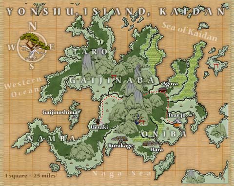
Link to full scale version - Yonshu Island, Kaidan map
As you can see, I have a variety of styles and Xara Xtreme let's me create all of them.
Michael
Link to full scale version of Ryukyo map...
Sometimes I get truly artistic and go for a particular style to match my needs. The following map was done using mountains and other elements that resemble ukiyo-e wood block print style, like the art of Hokusai or Hiroshige... This is the island of Yonshu, one of the 3 main islands of Kaidan, and where the entire Curse of the Golden Spear trilogy for Kaidan occurs.
Link to full scale version - Yonshu Island, Kaidan map
As you can see, I have a variety of styles and Xara Xtreme let's me create all of them.
Michael
Last edited by MichaelTumey on Mon Mar 26, 2012 5:06 pm, edited 1 time in total.
-
ewancummins
- Evil Genius
- Posts: 28523
- Joined: Tue Oct 25, 2005 1:35 pm
Re: Drawing a Map
Micheal, in designing Kaidan did you draw heavily from any particular period of Japanese history?
The maps look great, BTW!
The maps look great, BTW!
Delight is to him- a far, far upward, and inward delight- who against the proud gods and commodores of this earth, ever stands forth his own inexorable self.
-from Moby Dick (Hermann Melville)
-from Moby Dick (Hermann Melville)
-
MichaelTumey
- Evil Genius
- Posts: 451
- Joined: Sat Jun 11, 2011 3:23 pm
Re: Drawing a Map
Kaidan, while not truly Japanese, borrows heavily from before the Sengoku Period, more like the Kamakura Bakufu to the Ashikaga shogunate (1185 - 1500). There are few anachronistic elements taken from the Edo period, like the Yakuza (1600 - 1868), but most of Kaidan relates to the early feudal period of Japan. I also include a Teppou Bushi class (gunslinger of Japan), which is Oda Nobunaga time period, roughly 1570, though guns aren't a major aspect of the setting, I did not want to exclude arquebus wielding gunslingers as having a role in the setting, if people want to play them.ewancummins wrote:Micheal, in designing Kaidan did you draw heavily from any particular period of Japanese history?
The maps look great, BTW!