
There are thousands of pieces of user generated art in there....
Drawing a Map
Re: Drawing a Map
If that amazes you, try clicking the forums tab and then searching for stuff.... 
There are thousands of pieces of user generated art in there....
There are thousands of pieces of user generated art in there....
"I had a dream, which was not all a dream.
The bright sun was extinguish'd, and the stars
Did wander darkling in the eternal space..."
The bright sun was extinguish'd, and the stars
Did wander darkling in the eternal space..."
-
alhoon

- Invisible Menace

- Posts: 8818
- Joined: Thu Dec 11, 2003 6:46 pm
- Location: Chania or Athens // Greece
Re: Drawing a Map
I did for 2 hours. I found many interesting pieces.
"You truly see what a person is made of, when you begin to slice into them" - Semirhage
"I am not mad, no matter what you're implying." - Litalia
My DMGuild work!
"I am not mad, no matter what you're implying." - Litalia
My DMGuild work!
-
Strahdsbuddy

- Evil Genius

- Posts: 555
- Joined: Fri Apr 25, 2008 4:02 am
- Gender: Male
- Location: A Finger Lake
Re: Drawing a Map
http://i1211.photobucket.com/albums/cc4 ... medOut.jpg
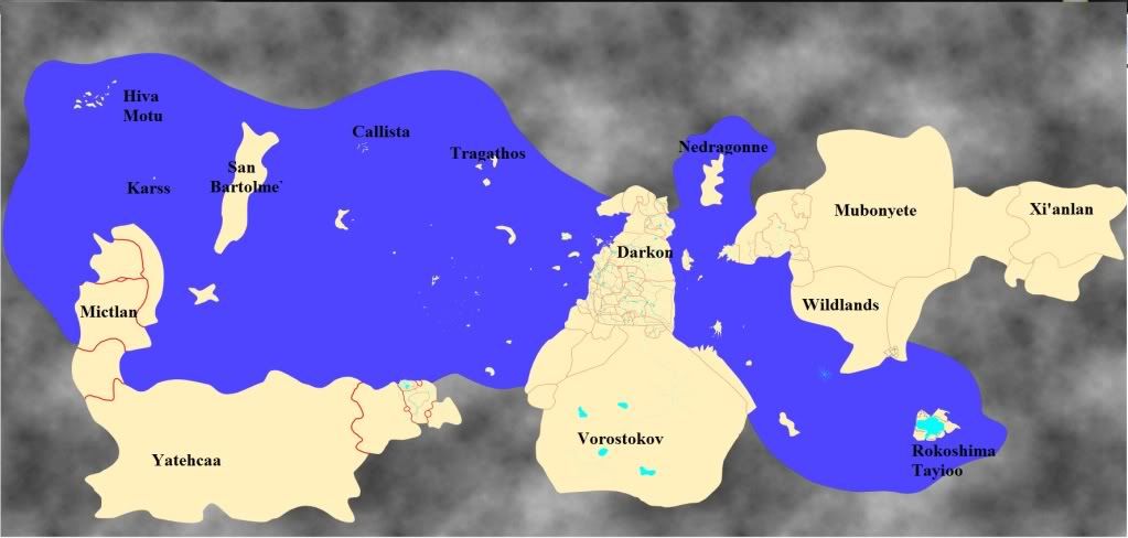
Here is the preliminary of the map I've been working on, including all the fan-made domains and islands of terror all placed on one map. This is essentially my own campaign's map, but I figured it was good to share. Labels available upon request, the Core should be easy to pick out, the Shadow Rift has been filled in, the warmer domains are east of Vechor and the Asian-themed domains are east of that. Mictlan and its derivative domains are in the west. Vorostokov and the cold domains (including the "Northlands") are in the south. Duskreach and Shadowborn are north of Darkon.
Specific domains that are missing include Bluetspur, which is on the moon, and the Nightmare Lands, which exists more or less astrally. Olympus is above the northern Core/Nocturnal Sea/Vechor. Vulnara is beneath the same region.
My own Carribean-inspired domain is composed of the small islands west of the Core. And in the interest of having the best of both worlds, the Antebellum version of Arkendale is in the eastern edge of the "New World" continent, alongside Souragne.
Last edited by Strahdsbuddy on Thu Nov 10, 2011 6:35 pm, edited 1 time in total.
Get the Core Genesis Project V4 in the Mausoleum.
Check out the Ravenloft Cartographic Society on Facebook
Check out the Ravenloft Cartographic Society on Facebook
-
DasSoviet

- Criminal Mastermind

- Posts: 111
- Joined: Tue Aug 12, 2008 7:08 am
- Location: Saudi Oilberta, Canuckistan
- Contact:
Re: Drawing a Map
Damn, Strahdsbuddy... that's bloody impressive! I mean, I am blown away by that! Wow...
What did you replace the Shadow Rift with there? I see two domains - Nidala and Avonleigh, or something else?
Really looking forward to what it looks like when you finish!
*ponders where he can fit in his Novia cluster*
What did you replace the Shadow Rift with there? I see two domains - Nidala and Avonleigh, or something else?
Really looking forward to what it looks like when you finish!
*ponders where he can fit in his Novia cluster*
Greetings, Citizens! A reminder: Happiness is mandatory. Those not enjoying themselves shall find themselves terminated.
-
Strahdsbuddy
- Evil Genius
- Posts: 555
- Joined: Fri Apr 25, 2008 4:02 am
- Gender: Male
- Location: A Finger Lake
Re: Drawing a Map
Don't pat me on the back too much, the map is essentially a rip of the MCS map Gomez made years ago. My shadowrift is filled with Sanguinia in the south, as suggested by Gomez, Fairhafen in the north, Vultharesk int he SW, Seradan along the Borcan border, Staunton Bluffes int he NW corner and Addar's wood sharing a border with Staunton Bluffs, Falkovnia and Darkon.
Sanguinia makes the most sense (again, Gomez's idea, not mine) because all the rivers conspicuously match up with rivers in the southern Core. Fairhafen came to me much later, and even though it isn't one of those super popular domains, I think its connection to fairytales is a good foil to its neighbor, Tepest, as well as a good domain to have sitting atop the northern Shadow Rift, which is still down there, full of fey. As an added "coincidence" they speak Falkovnian in Fairhafen, so they are neighbors too, if not allies.
That is an interesting map you have there, DasSoviet. Where could I learn more about Novia? By civilized lands, do you mean higher tech levels than elsewhere in the setting? If so, I'd say it could fit well around the SHining Bay (obviously) or maybe as part of the coast of the new world culster, with wild places like Tsuu-e-teke and Yacheteh as an untamed backdrop.
Get the Core Genesis Project V4 in the Mausoleum.
Check out the Ravenloft Cartographic Society on Facebook
Check out the Ravenloft Cartographic Society on Facebook
-
MichaelTumey
- Evil Genius
- Posts: 451
- Joined: Sat Jun 11, 2011 3:23 pm
Re: Drawing a Map
While I don't specifically map Ravenloft realms, I am a pro cartographer at least for RPG settings, some for my own and many for other publishers through commission. I am even a freelancer for Paizo at this time.
Here's a map of one of the islands of the Kaidan archipelago, which is the nation that my Japanese horror setting Kaidan takes place. The introductory mini-arc is set on Yonshu, one of the four main islands of Kaidan. In this map, I referred to landscape illustrations created by Hokusai and Hiroshige, who were ukiyo-e print artists from the 19th century, especially the mountains.
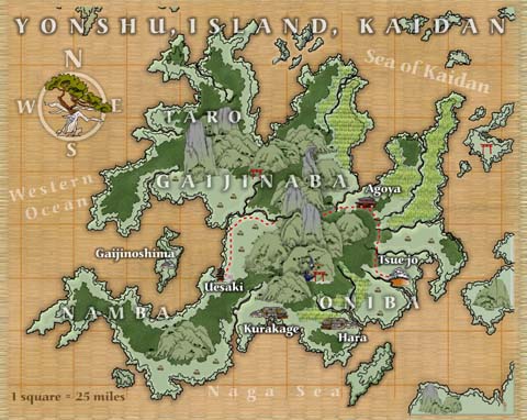
Here's the large format version link - Yonshu Island.
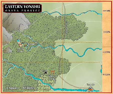
Here's one of just the eastern side of Yonshu - this map is featured in the 2nd adventure of the mini-arc:
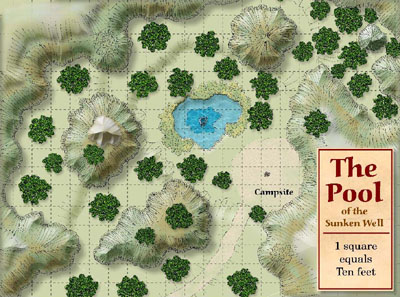
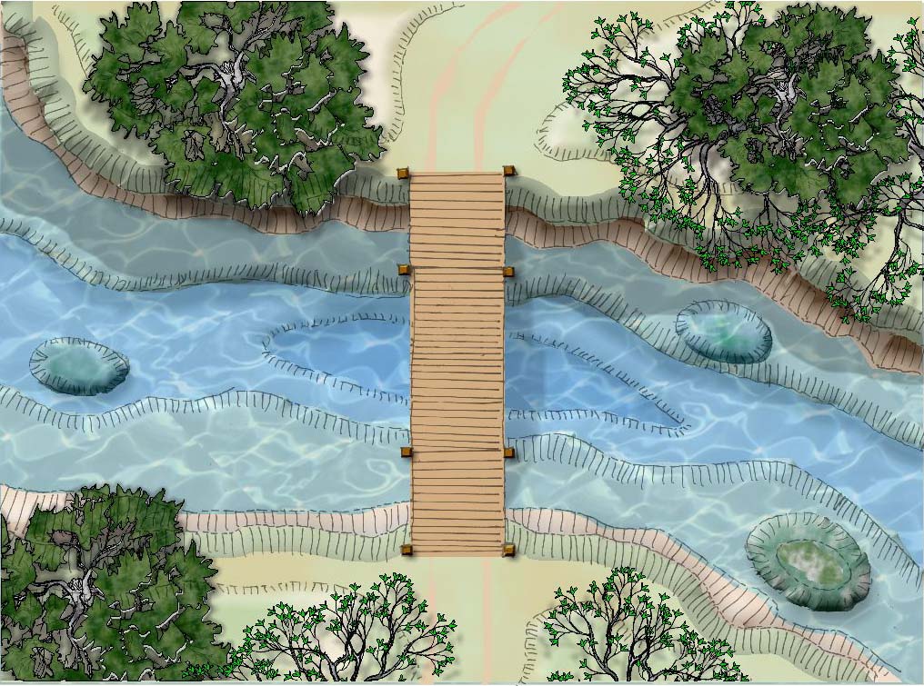
Here's a map, almost at encounter scale (perhaps 1" = 10') - an encounter site in the 1st adventure of the mini-arc.
Obviously my style of map is more hand-drawn. However, I use Xara Xtreme - my graphics app of choice, to create all the color, beveled shapes, etc that sit beneath the hand-drawn work.
Michael
Here's a map of one of the islands of the Kaidan archipelago, which is the nation that my Japanese horror setting Kaidan takes place. The introductory mini-arc is set on Yonshu, one of the four main islands of Kaidan. In this map, I referred to landscape illustrations created by Hokusai and Hiroshige, who were ukiyo-e print artists from the 19th century, especially the mountains.
Here's the large format version link - Yonshu Island.
Here's one of just the eastern side of Yonshu - this map is featured in the 2nd adventure of the mini-arc:
Here's a map, almost at encounter scale (perhaps 1" = 10') - an encounter site in the 1st adventure of the mini-arc.
Obviously my style of map is more hand-drawn. However, I use Xara Xtreme - my graphics app of choice, to create all the color, beveled shapes, etc that sit beneath the hand-drawn work.
Michael
-
alhoon
- Invisible Menace
- Posts: 8818
- Joined: Thu Dec 11, 2003 6:46 pm
- Location: Chania or Athens // Greece
Re: Drawing a Map
How you make those lines on the cliffs?
"You truly see what a person is made of, when you begin to slice into them" - Semirhage
"I am not mad, no matter what you're implying." - Litalia
My DMGuild work!
"I am not mad, no matter what you're implying." - Litalia
My DMGuild work!
-
MichaelTumey
- Evil Genius
- Posts: 451
- Joined: Sat Jun 11, 2011 3:23 pm
Re: Drawing a Map
A pen?alhoon wrote:How you make those lines on the cliffs?
The way I create maps:
1. I create vector shapes of all identifiable objects - roads, buildings, river banks, coasts, base of hills/cliffs/mountains, etc, then print to large format at 18" x 24", 24" x 36" or 36" x 48"
2. I place tracing paper on top of the print, and trace the major objects with a pen (hand-drawn). Then I detail all objects - crosshatches for solid ground (for underground/dungeon maps), "lines at edge of cliffs, hills, mountains", ground and plant detail, etc.
3. Then I scan these into TIF format as B/W, import to Photoshop and convert to grayscale 300 ppi.
4. Import to Xara Xtreme, then create beveled shapes, apply colors, feathering, transparency and shadowing in stacked layers.
5. Export to appropriate dimensions and final format (PDF, TIF, JPG, whatever that's needed).
Its pretty straight forward.
For example here is an up-close section of a city map I am working on for Paizo Publishing, showing only hand line-work. At some point all my maps are just line-work:
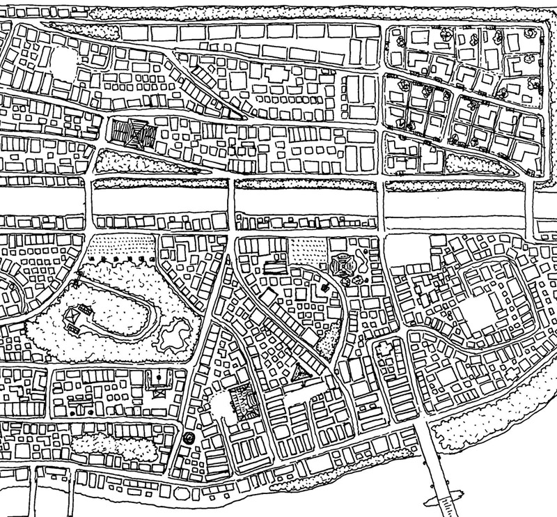
Here is another finished encounter-scale map, in larger format so you can more easily see the hand-work detailing:
Michael
-
alhoon
- Invisible Menace
- Posts: 8818
- Joined: Thu Dec 11, 2003 6:46 pm
- Location: Chania or Athens // Greece
Re: Drawing a Map
Interesting technique. It requires a good and large printer and scanner though. But still the results feel more... personal. I asked about the lines etc because they didn't seem computer generated.
"You truly see what a person is made of, when you begin to slice into them" - Semirhage
"I am not mad, no matter what you're implying." - Litalia
My DMGuild work!
"I am not mad, no matter what you're implying." - Litalia
My DMGuild work!
-
MichaelTumey
- Evil Genius
- Posts: 451
- Joined: Sat Jun 11, 2011 3:23 pm
Re: Drawing a Map
Yeah, I run my own graphic design studio/digital print shop. I have a large format b/w digital scanner/printer, as well as large format inkjet printer inhouse. Although I also have an 11" x 17" flatbed scanner, my maps tend to be larger than that, so it would be a pain in the butt, but I could scan large format drawings with multiple scans stitched back together - and have done that in the past. I prefer to scan as a single piece at full size however.
I also do strictly digital designs in some maps, but most publishers prefer the quality of a good hand-drawing, so that's what I do mostly.
Michael
I also do strictly digital designs in some maps, but most publishers prefer the quality of a good hand-drawing, so that's what I do mostly.
Michael
-
Strahdsbuddy
- Evil Genius
- Posts: 555
- Joined: Fri Apr 25, 2008 4:02 am
- Gender: Male
- Location: A Finger Lake
Re: Drawing a Map
Those are pretty slick, Michael. I have admired the Paizo maps I've seen, did you draw many of them? Like the Ustalav map in particular, I liked that one a lot.
I have trouble with realistic coastlines personally. What are some tips for breaking up those straight lines?
I have trouble with realistic coastlines personally. What are some tips for breaking up those straight lines?
Get the Core Genesis Project V4 in the Mausoleum.
Check out the Ravenloft Cartographic Society on Facebook
Check out the Ravenloft Cartographic Society on Facebook
-
MichaelTumey
- Evil Genius
- Posts: 451
- Joined: Sat Jun 11, 2011 3:23 pm
Re: Drawing a Map
As far as my maps of Paizo, I've received my first commission for them last month, and it hasn't been published yet - probably a December release, so no you haven't seen any of my Paizo maps yet. I've been told I will be working on their upcoming Shackles and Skulls, their pirate adventure path as a next project.
Coastlines - I tend to hand-draw these with plenty of squiggles for small inlets, outcroppings of rock, peninsulas and bays. I like interesting coastlines. In my hand-drawn coastlines, I tend to draw two parallel lines, one for the shore meeting the water and a second line to deliniate the heights rising next to the shore. If I determine a wide beach, then the parallell lines separate widely, while on cliff lined shores these lines are very close together.
Looking at my modus operandi in the post above my last one, you'll note that I create the basic lines for coasts, rivers, mountains and other geographic features as vector drawn shapes in a drawing program, then I output to large format. I usually don't define the details of a rough coastline in the vector, rather its general shape. Then I as trace over it with a pen on tracing paper I follow the coasts only generally, but get crazy with the squiggles to really define a rough and natural looking shoreline.
Here's an old map of mine for a map contest entry with those parallel lines I was speaking of...
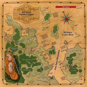
Link to larger version of this map - Archean Trade League Map
Michael
Coastlines - I tend to hand-draw these with plenty of squiggles for small inlets, outcroppings of rock, peninsulas and bays. I like interesting coastlines. In my hand-drawn coastlines, I tend to draw two parallel lines, one for the shore meeting the water and a second line to deliniate the heights rising next to the shore. If I determine a wide beach, then the parallell lines separate widely, while on cliff lined shores these lines are very close together.
Looking at my modus operandi in the post above my last one, you'll note that I create the basic lines for coasts, rivers, mountains and other geographic features as vector drawn shapes in a drawing program, then I output to large format. I usually don't define the details of a rough coastline in the vector, rather its general shape. Then I as trace over it with a pen on tracing paper I follow the coasts only generally, but get crazy with the squiggles to really define a rough and natural looking shoreline.
Here's an old map of mine for a map contest entry with those parallel lines I was speaking of...
Link to larger version of this map - Archean Trade League Map
Michael
-
Jester of the FoS

- Jester of the Dark Comedy

- Posts: 4536
- Joined: Wed Dec 03, 2003 12:19 am
- Location: A Canadian from Canadia
Re: Drawing a Map
Updated image:

I might need to roughen up the terrain or add more mountains. They feel a little sparse now.
I might need to roughen up the terrain or add more mountains. They feel a little sparse now.
-
alhoon
- Invisible Menace
- Posts: 8818
- Joined: Thu Dec 11, 2003 6:46 pm
- Location: Chania or Athens // Greece
Re: Drawing a Map
Personally, I would also add some mist around the map and in the shadow rift.
"You truly see what a person is made of, when you begin to slice into them" - Semirhage
"I am not mad, no matter what you're implying." - Litalia
My DMGuild work!
"I am not mad, no matter what you're implying." - Litalia
My DMGuild work!
Re: Drawing a Map
Looking good Jester.
I do agree you need more mountains or something to make the height more obvious in places.
I'd also suggest muting the colours a little. Add some more yellow into the base green for grassland, and tone the sea more grey blue than royal blue.
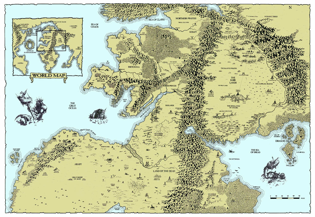
Another neat little tip on Photoshop to add the multiple wave lines on a coastline effect you see one some maps (e.g. http://sherohman.org/~dave/rpg/wfrp/world_map.jpg). Is to select the shape of your landmass, then hit select > modify > expand and expand it by a few pixels. This gives you a selected shape a bit larger but in same proportions as the landmass. Add a stroke to it. Then rinse and repeat a few times each time lowering the opacity slightly. If you want to break up the lines a little add a layer mask and take a grungey stippleed brush and rub some bits out or fade some bits away by lowering the brush opacity when using the mask.
I do agree you need more mountains or something to make the height more obvious in places.
I'd also suggest muting the colours a little. Add some more yellow into the base green for grassland, and tone the sea more grey blue than royal blue.
Another neat little tip on Photoshop to add the multiple wave lines on a coastline effect you see one some maps (e.g. http://sherohman.org/~dave/rpg/wfrp/world_map.jpg). Is to select the shape of your landmass, then hit select > modify > expand and expand it by a few pixels. This gives you a selected shape a bit larger but in same proportions as the landmass. Add a stroke to it. Then rinse and repeat a few times each time lowering the opacity slightly. If you want to break up the lines a little add a layer mask and take a grungey stippleed brush and rub some bits out or fade some bits away by lowering the brush opacity when using the mask.
"I had a dream, which was not all a dream.
The bright sun was extinguish'd, and the stars
Did wander darkling in the eternal space..."
The bright sun was extinguish'd, and the stars
Did wander darkling in the eternal space..."